The spectacular splash and dash of Horseshoe Basin
NORTH CASCADES NATIONAL PARK — For two waves of strike-it-rich dreamers — first in the 1890s, then in the late 1940s — Horseshoe Basin in the upper Stehekin River Valley ultimately proved to be a bust for hundreds of prospectors who chipped and probed and drilled its steep rock walls in search of precious metals and mineral riches.
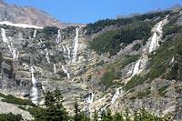
However, the real treasure waiting to be discovered in Horseshoe Basin is its mother lode of scenery, most notably its amazing, wide-angle display of multiple waterfalls and cascades — six, seven, eight, maybe more — that tumble down its amphitheater-like northern wall. In its way, it is Washington's answer to Africa's Victoria Falls, and even after this exceptionally dry summer, the falls are still flowing at a rate that makes this scene worth the above-average effort needed to experience it in person: an 8.2-mile, up-and-down, one-way walk from Cascade Pass in North Cascades National Park. On the plus side, no pick ax or hand drill is required.
Neither is a machete, which in recent years some visitors to the basin probably wished they had in their packs. The brushy 1.5-mile spur trail into Horseshoe Basin (accessed from the main east-west Stehekin River Trail below Cascade Pass) had become overgrown in places to the point of near impenetrability.
In mid-August, though, a North Cascades National Park trail crew hacked away years of overgrowth, particularly several dense sections of slide alder. Thus a formerly clogged pathway is now a dejungled, uphill stroll to the rocky meadows below the falls.
A prospecting past
Historically, Horseshoe Basin (not to be confused with Horseshoe Basin in the Pasayten Wilderness) has not been especially hospitable to visitors. The natural forces that give the basin its grand visual appeal are what also broke the will of determined prospectors and miners roughly a century (and half-century) ago.
Jesse Kennedy, chief of cultural resources for North Cascades National Park, points out that mining activity was extensive in the valleys and basins near Cascade Pass, an area that today attracts thousands of hikers annually for its gorgeous, long-distance, deep-valley views.
Horseshoe Basin, Kennedy says, was home to six significant mines: three in the upper basin (Davenport, Upper Horseshoe Basin and Stinson) and three in the lower basin (Black Warrior, Blue Devil and Golden Gate).
A 230-pound nugget of silver was extracted from the Davenport mine and was displayed in Chicago at the Columbian Exposition of 1893, the world's fair of its time. "That wasn't a record," Kennedy said. "But it's really big, and for these mines it was notable."
It helped spark a prospecting rush in the North Cascades during the 1890s. One claim in the area sold for $30,000, a huge amount in that day. More than 40 claims were staked in Horseshoe Basin alone. Miners prowled the ridges and valleys in search of their fortunes.
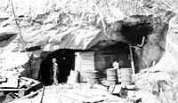
The biggest operation was the Black Warrior mine, where the owners drilled hundreds of feet into the rock and constructed a mining camp with large cabins in the lower basin. (Today, this site is a rough-hewn backcountry camp, Basin Creek.)
Yet mining costs were high, profits were low and weather conditions were tough, all of which slowed mining activity within a decade.
Activity revived in the mid-1940s. The state envisioned a road over Cascade Pass. The river road from Stehekin Landing was extended beyond Cottonwood Camp all the way to what is now Basin Creek Camp. A ski lift-style aerial tramway (involving more than 6,000 feet of cable) to transport ore was constructed to connect the upper and lower basins.
This time the quest was not for gold and silver. "There was a real shortage of lead, copper and zinc after World War II," Kennedy said. "That's what people were looking for in this second mining period."
Mind the mines
A huge snow slide in the early 1950s destroyed the extended road and flattened all the facilities of the Black Warrior Mining Co., bringing mining activity to its ultimate end. Equipment was eventually sold and mostly removed from the valleys and basins. A few strands of cable can still be spotted today in Horseshoe Basin.
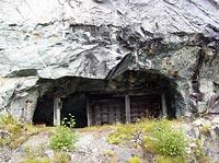
The Black Warrior mine, included on the National Register of Historic Places, is the most accessible of the Horseshoe Basin mines, a large horizontal hole sitting near the base of the farthest-left cascade in the basin's array of waterfalls.
A small plaque sits at its entrance, and no barriers prevent entry, but the Park Service discourages people from entering. Flooded chambers, heaps of rockfall, unpredictable oxygen levels, rotting timbers supporting unstable rock — all good reasons to avoid going in, Kennedy says.
"I'm certified to go into the mines, but I'm scared of them," Kennedy said. "For me to enter, I have to have a permit and be accompanied by a certified mineral engineer. We must carry gas detectors and follow very strong safety procedures. We don't just wander into mines."
But wandering into Horseshoe Basin, with its recently cleared spur trail, its inviting display of waterfalls that drain imposing Ripshaw Ridge high above and its splendid across-valley views of Trapper and Spider mountains to the south? Worth every step, Kennedy would agree. "It's a beautiful place," he said.
When freelancer Terry Wood isn't writing outdoors stories, he's an editor at REI. Contact him at farhiker@rei.com.
Getting there
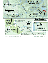
Drive to Marblemount, 46 miles east of Burlington on Highway 20. In town, bear right on the Cascade River Road and cross the Skagit River. Drive 10 miles on pavement, 13.5 more miles on a decent dirt road to the Cascade Pass trailhead, 3,600 feet. A Northwest Forest Pass is required to park.
The effort
An in-and-out trek to Horseshoe Basin involves 16.4 miles with two 1,800-foot climbs to Cascade Pass and a separate, 1,200-foot climb into the basin — a manageable but demanding day hike for very fit, athletic explorers. As a less-taxing alternate, some people may prefer to secure a free backcountry permit and camp overnight at Pelton Basin, a half-mile below Cascade Pass.
The hiking route
Climb 3.7 miles to Cascade Pass, 5,392 feet, itself a well-known and worthwhile day-hike destination. The popular climb to Sahale Arm begins a few paces north. You, however, descend 3 miles into the Stehekin River Valley. (This can be a tough, mostly shadeless grunt on the return trip.) The well-marked junction with the Horseshoe Basin Trail lies at 3,600 feet. In 1.5 miles, the trail climbs to approximately 4,800 feet. If you want to stand at the base of the falls, you must pick your way through rocks and brush to do so.
The old route: Before the floods of October 2003, the preferred approach to Horseshoe Basin was to ride Lady of the Lake up Lake Chelan to Stehekin Landing, then hop on the shuttle for a 23-mile ride to Cottonwood Camp (2,800 feet) on the mostly unpaved Stehekin River Road. From there it was a modest 2.5-mile hike to the Horseshoe Basin spur trail. Numerous flood-caused washouts closed the western 10 miles of the road, which now ends at Car Wash Falls in the High Bridge area.
Why go now
Fall colors, fewer flies (highly annoying in summer), smaller crowds. But watch freezing levels, and go prepared for any kind of weather.
More information
North Cascades Visitor Center in Sedro-Woolley, 360-856-5700, Ext. 515.
Wilderness Information Center (backcountry permits), 360-873-4500, Ext. 39. www.nps.gov/noca.